CoffeeMap.dev
HomeAboutExpertiseContactالعربية

Brewing Data intoActionable Geospatial Insights

CoffeeMap.dev, created by Amin Adnan Gasim, is a geospatial engineering platform focused on enterprise GIS, web mapping, GeoAI, and BIM integration—transforming complex spatial data into clear, actionable intelligence for infrastructure and environmental applications.

CoffeeMap Geospatial Platform

What We Do

End-to-end geospatial solutions spanning data collection, analysis, and visualization

Enterprise GIS

Scalable geospatial infrastructure solutions powered by ArcGIS and PostGIS for mission-critical operations.

Web Mapping

Interactive web mapping platforms using Leaflet, Mapbox, and Cesium for immersive data visualization.

GeoAI & Remote Sensing

Machine learning and satellite analysis using Google Earth Engine for actionable intelligence.

BIM & Infrastructure

Unified 3D infrastructure management bridging CAD, BIM (Revit), and GIS for digital twins.

Featured Projects

Explore our portfolio of geospatial engineering solutions across humanitarian and infrastructure domains
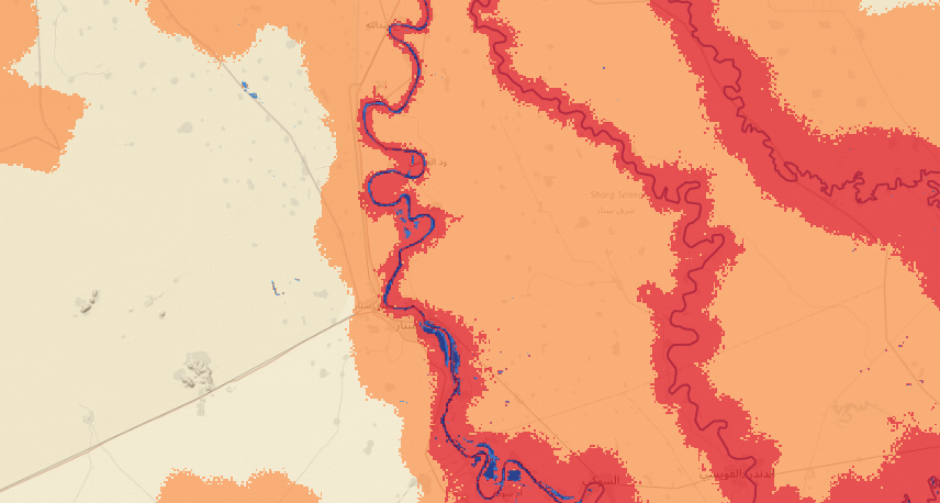
Blue Nile Flood Risk
GeoAI - Hydrology
Blue Nile Flood Risk

Client-side GeoAI flood risk mapping for Sennar and Gezira, Sudan — Sentinel-1 SAR flood detection, DEM slope, rainfall and river distance combined in an adjustable risk model, all computed in the browser.

Sentinel-1 SAR
MapLibre GL JS
Planetary Computer
Sentinel Hub
Open-Meteo
Overpass API
Next.js
TypeScript
View Demo
Blue Nile Flood Twin
GeoAI - Hydrology
Blue Nile Flood Twin

An animated 3D flood of Sennar, Sudan during the September 2020 Blue Nile flood — terrain, extruded buildings, rising water, rain following rainfall and buildings coloured by water depth, with the same animation exported to video.

Three.js
WebGL
WebCodecs
Digital Twin
Copernicus DEM
Sentinel-2
Planetary Computer
Python
Next.js
TypeScript
View Demo
Riyadh Urban Heat & Tree Canopy Equity
GeoAI - Environment
Riyadh Urban Heat & Tree Canopy Equity

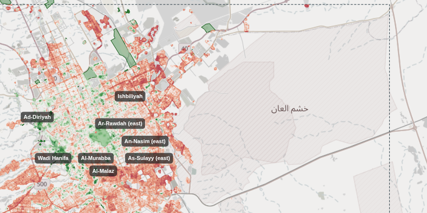
Client-side GeoAI for Riyadh — Landsat surface temperature hotspots, Sentinel-2 NDVI and tree canopy, OSM trees and parks, a TensorFlow.js heat-risk model and canopy-equity priority zones for planting, all computed in the browser.

Landsat 8/9
Sentinel-2
TensorFlow.js
MapLibre GL JS
Planetary Computer
ESA WorldCover
NASA POWER
Overpass API
Next.js
TypeScript
View Demo
GeoAI Crop Monitoring
GeoAI - Agriculture
GeoAI Crop Monitoring

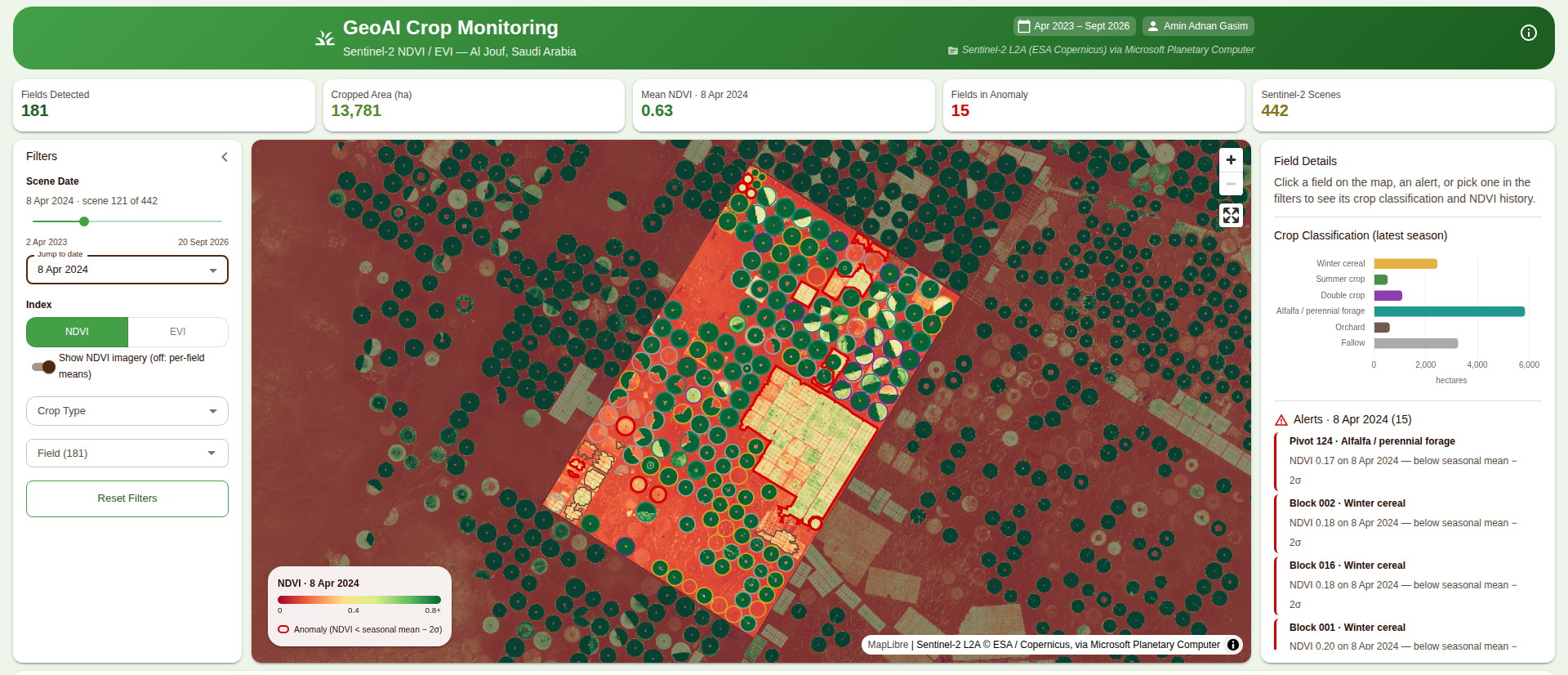
Sentinel-2 crop monitoring for irrigated farms in Al Jouf, Saudi Arabia — auto-detected centre pivots, NDVI/EVI time series, crop classification and anomaly alerts.

Python
OpenCV
Rasterio
NumPy
STAC API
Planetary Computer
Sentinel-2
Next.js
TypeScript
MapLibre GL JS
Chart.js
View Demo
Serverless GeoAI Architecture
Interactive Workflow
Serverless GeoAI Architecture

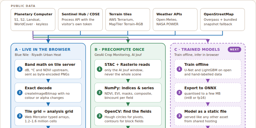
Interactive architecture of the GeoAI dashboards: two live routes (compute in the browser, or precompute once and stream imagery) and a planned third for trained models, with no VPS, database or Python at runtime.

Architecture
Serverless GeoAI
Planetary Computer
STAC
MapLibre GL JS
TensorFlow.js
ONNX Runtime Web
Static hosting
View Demo
Geospatial QA/QC Workbench
Interactive Workflow
Geospatial QA/QC Workbench

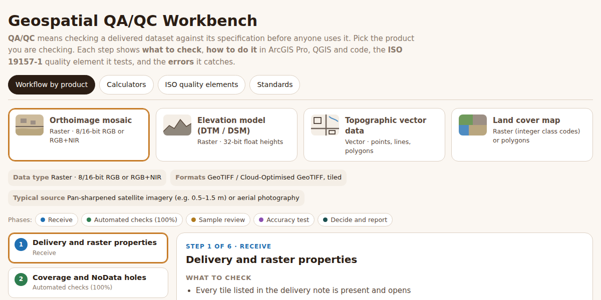
Interactive QA/QC workflows for orthoimagery, elevation models, topographic vectors and land cover — what to check, how in ArcGIS Pro, QGIS and code, the ISO 19157-1 element behind each step, plus sampling, accuracy and confusion-matrix calculators.

ISO 19157-1
ISO 2859-1
ArcGIS Pro
QGIS
PostGIS
GDAL
Python
Data Quality
Knowledge Management
View Demo
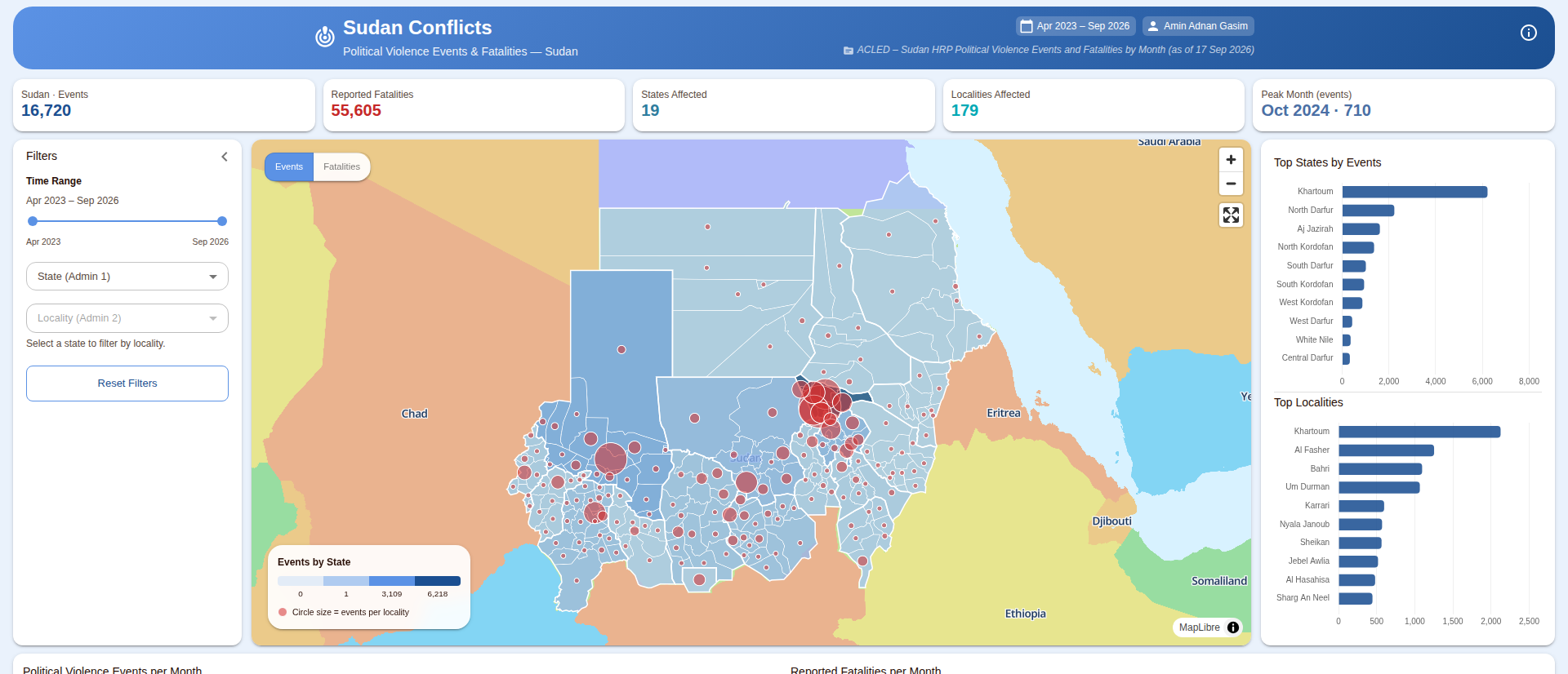
Sudan Conflicts
Web Mapping
Sudan Conflicts

Conflict monitoring dashboard mapping ACLED political violence events and fatalities across Sudan since April 2023, by state, locality and month.

Next.js
TypeScript
MapLibre GL JS
Chart.js
Material UI
Node.js
GeoJSON
ACLED Data
View Demo
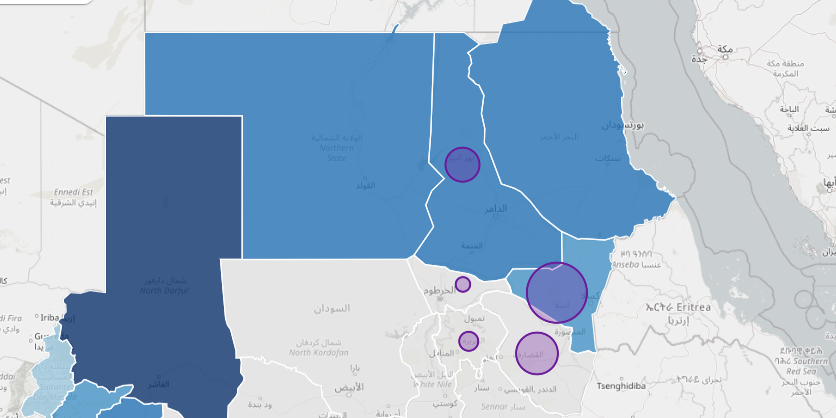
Sudan Flood Dashboard
Web Mapping
Sudan Flood Dashboard

Interactive humanitarian dashboard tracking flood crisis, displacement, and disease outbreaks across Sudan states using real OCHA data.

Next.js
TypeScript
MapLibre GL JS
Chart.js
Material UI
GeoJSON
OCHA Data
View Demo
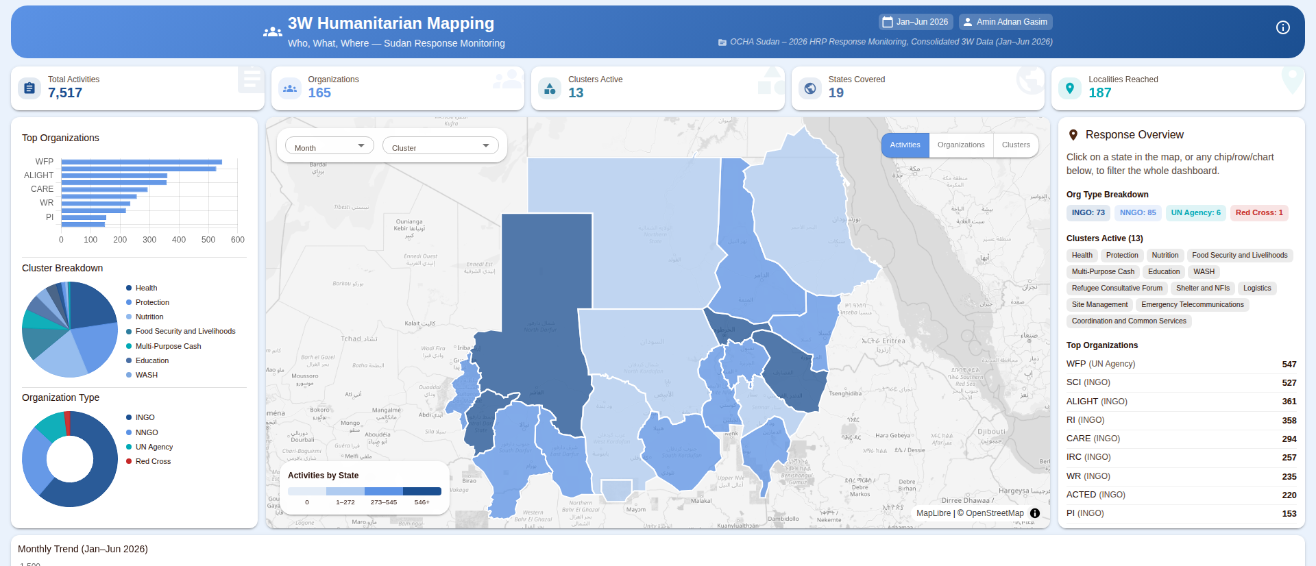
3W Humanitarian Mapping
Web Mapping
3W Humanitarian Mapping

Who What Where dashboard tracking Sudan humanitarian activities, active partners, and coverage gaps using real OCHA 3W response monitoring data.

Next.js
TypeScript
MapLibre GL JS
Chart.js
Material UI
Node.js
GeoJSON
OCHA 3W Data
View Demo
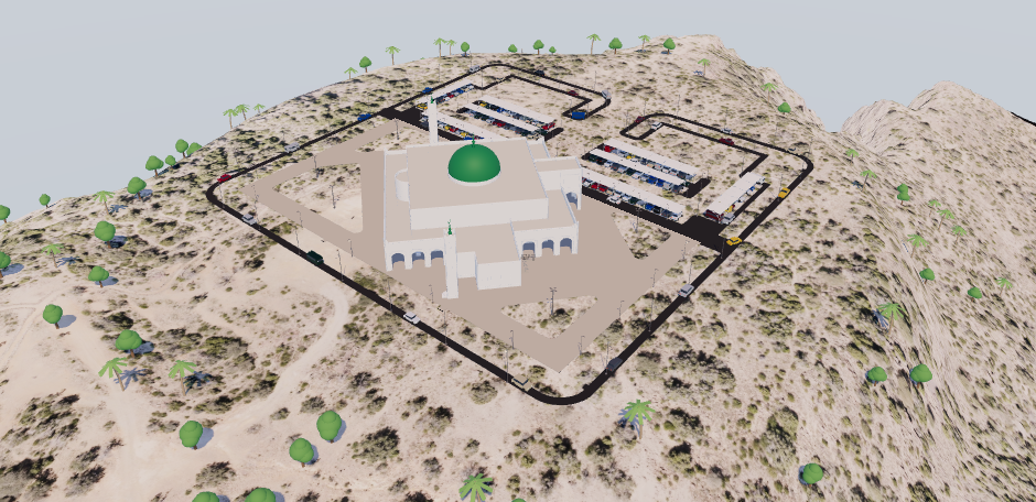
3D Mosque Viewer
GIS-BIM
3D Mosque Viewer

Interactive 3D environment of a mosque site in Aseer, Saudi Arabia — clickable BIM data for every Revit element (Saudi codes, quantities, SAR costs, lifecycle), DTM terrain with orthophoto, live traffic, day / night lighting and a survey drone flying a photogrammetry mission that builds up its photo overlap on the ground.

Three.js
BIM
Revit
glTF
WebGL
DTM
Photogrammetry
GDAL
Next.js
TypeScript
View Demo

Latest Insights

Technical deep dives and best practices from our geospatial engineering experience

GeoAI
28 Sept 2026
Serverless GeoAI: The Architecture Behind CoffeeMap.dev

How three satellite dashboards run with no VPS, no database and no Python at runtime: two routes, six patterns and one rule for where each computation belongs.

Read More →
GeoAI
28 Sept 2026
Flood Risk Mapping on the Blue Nile, Entirely in the Browser

Sentinel-1 radar, terrain tiles, rainfall and OpenStreetMap rivers become a flood-risk screening model for Sennar and Gezira, with no server at all.

Read More →
GeoAI
28 Sept 2026
Where Riyadh Needs Trees Most

Landsat heat, Sentinel-2 vegetation, WorldCover and OpenStreetMap on a 1.6-million-cell grid, client-side, to rank the blocks where one more tree matters most.

Read More →
GeoAI
28 Sept 2026
Crop Monitoring for Al Jouf Without a Server

Centre-pivot detection, NDVI/EVI time series, crop classification and anomaly alerts, built offline in Python and served as static files plus live tiles.

Read More →
Enterprise GIS
28 Sept 2026
A Practical QA/QC Workbench for Geospatial Data

What to check, how to check it in ArcGIS Pro, QGIS and code, and which ISO 19157-1 element it tests, for orthoimagery, elevation models, vector data and land cover.

Read More →

Get in Touch

Have a project in mind? Let’s discuss how we can help with your geospatial needs.

Name *
Email *
Message *
Connect With Us

X (Twitter)

@coffeemapdev

LinkedIn

@amiin211

GitHub

@amiin211

Email

[email protected]

CoffeeMap.dev

Brewing Data into Actionable Geospatial Insights

Created by Amin Adnan Gasim

© 2026 CoffeeMap.dev. All rights reserved.